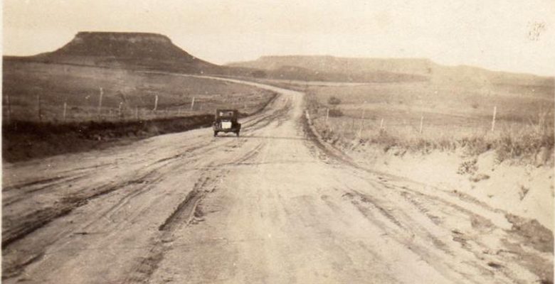
A reader sent in this photo, and he’s looking to identify the location.
Here’s what Phillip tells us:
Westward bound somewhere between Amarillo and Mountain Air or somewhere.
August of 1927, maybe in the afternoon, two stranded barbed wire and cedar posts, a tree? Birds?By the listing of towns my aunt put in her foolscap paper homemade dairy, Highway 60!
Very light traffic, drying puddles, no buildings in sight, clear road ahead to the magnificent mesa!
We’ve got John Mulhouse, who is responsible for all those excellent City of Dust articles, on the case. But we’re also open-sourcing the adventure.
How about it? Anyone have any clue where this picture might have been taken?


Oh, my !!! Be still my heart ! COÑO, ¡ Ya puedo vivir !
¡Tú haz puesto esperanza en mi coraz?n! Cando llego en Chuco, vamo a parandear, umpoco. Not really, but thanks, I am so impressed !
Felipe.
What a jackass…
Stone, ¡ tienes razón, tonto que soy! When it comes to family and discovering family history, I tend to get a little excited. I am very appreciative of Richard and his putting the picture on his blog for someone to help me find out where that Mesa is when my father drove through there in 1927. I have no problem being overly enthusiastic and zealous in my appreciation. I’ve been called worse !! LOL
Hyperbole, and a touch of literary license.
Richard ,
Bear with me as I enter the 21st century: My mistakes and my presumptions. I really appreciate your posting my quest in your world. I have purchased the book on highway 60 that John has described. Will be a treat!
Phillip, Map Sleuths, et al,
I think that the view is facing north in the late afternoon. Right? Look at the shadows. In the near distance, the road turns left, or west, if my assumptions are correct. Now, Highway 60 hardly runs that direction. We have to assume that either they weren’t on Highway 60, or the road has changed. Imma bet the road has changed, and the old road ran a little west of the current road, and the picture was taken between Silio and Willard.
Your thoughts?
Thanks, it gets confusing, not knowing if their westerly migration was swinging toward thr north or the south, or if the sun was dipping toward the west. Or, if the developer of the print even had the negative in correctly. Either way, even if my dad was lost out there, there was a small, isolated mesa out there between Higgins, Canadian, Miami, Pampa, Birger,Panhandle , Amarillo, Hereford, Farwell,
and the New Mexico border.
Then, Clovis, Vaughn and Mountain Air and Socorro. And then on to the Petrified
Forest and St. John’s. Toooo much territory, not enough info: just a mesa! Sorry.phil
The onlyest place where I could see them going north would have been when they broke away to go up to visit family in Borger. They would have stopped going south west on the 60(?), and take the now 152, NW through Skelleytown to get to Borger. Then after visiting there, they would have through either Panhandle or Fritch to reconnect with the 60. I see, but my marker has it partially blocked, there is a “Ali?bates” National Monument there which I will check out rat Now !!
Maybe John can tell me if the mesa is netween Silio and Willard. And I dunno for sure if they were in Texas or New Mexico. They were not geographers and how well was the border marked?
Nope, Not Alibates; somewhere else !! 🙁
¡El está en el correo!
Somewhere between Miami, OK, and Miami, TX, and Socorro and the Petrified Forest, that mesa exists, and no can discourage or deter Quixote in his quest.
Interesting: when cinco and Piedras Azules are placed between the less than and greater than symbols to indicate Spanish Language quotations, they are deleted.
¡Qué triste!
El cinco.
No Piedras Azules can