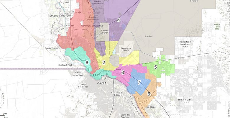
Here’s a link to the City of El Paso’s map of the City’s Representative districts.
It’s a hash. One can only wonder what the people who allocated the districts were thinking.
Look at District 8. District 8 includes the Willows, and Segundo Barrio. The two disparate neighborhoods are linked by that little bit of Paisano that runs along the river below UTEP. Don’t you think that the people who live in the old money El Paso Country Club precincts have more in common with the new money precincts by the Coronado Country Club? Wouldn’t lumping those two demographics together make more sense than grouping the people who live in the Upper Valley with the people who live in the Chamizal?
Who do you think the District 8 Representative represents?
Look at District 4. Precinct 60, that neighborhood up there off of Zion, is separated from the rest of the district by Fort Bliss, and linked to District 4 by a narrow strip of land that runs along the ridge of the Franklin Mountains.
I’ve been along the ridge. Nobody lives there.
It looks like all the precincts south of the freeway are divided between more populous districts north of the freeway, so the voices of the voters south of freeway are drowned out by the voters north of the freeway.
I’m not going to say it’s racist, but I don’t mind calling it classist. These gerrymandered districts effectively rob the people south of the freeway, the people who live in neighborhoods that are among the poorest in the nation, of a voice on City Council.
City representatives are going to pander to their constituents that vote, and who contribute to their campaigns.
This year is a redistricting year. Every ten years, after the census, the City is charged with re-drawing the district boundaries. According to the City Charter:
On or before September 1 next following the publication of the results of each decennial United States census, each Representative shall nominate one qualified voter from his or her district and the Mayor shall nominate one qualified voter from the City at large. Upon approval by the Council, these nominees shall comprise the Districting Commission. . . . The Commission shall make recommendations to the Council concerning adjustments of the boundaries of the Representative districts. Upon receiving the Commission’s recommendations, the Council shall review the population of each district, and as soon as possible, shall change the boundaries thereof as necessary to insure substantial equality in the populations of the districts.
I’m thinking that the incumbent City Reps will fight to keep their districts mostly unchanged. The system has worked for them so far. But half of the City Representatives will have termed out by the time of the next election for their seats. They’ve got no dog in the fight.
El Paso needs contiguous districts that represent the community.
Kind of like how our local school districts are divided, isn’t it? Antiquated ideas perpetuated by self-interest and greed? I think you make a good point, but the question is, how do we get those who will make these decisions to open their beady little eyes, and their greedy little minds far enough to see that a serious revamp is long overdue?
AT ONE TIME, THE DISTRICTS WERE BOUNDED BY THE FREEWAY. 1990 REDISTRICTING MADE DRASTIC CHANGES.
District 8 was about making sure the country club was in charge of DTEP.
ACTUALLY, IT WAS AN ATTEMPT TO GET DOWNTOWN HISPANIC AREA A CHANCE TO CONTROL THERE AREA, BUT THE WILLOWS OUT VOTED THEM.
THIS BEGAN AFTER THE 1990 CENSUS(IF I RECALL CORRECTLY). I SAT IN ON SOME OF THE MEETINGS. IT WAS AN ATTEMPT TO GIVE HISPANIC AREAS MORE INFLUENCE…YET IT RESULTED IN DILLUTING THE HISPANIS VOTE AT THE TIME. NOW NO NEED.
Also, take a look at our State Representative maps: https://epcountyvotes.com/maps/state_house_of_representatives_congressional.
Northeast El Paso has nearly NOTHING in common with West El Paso yet they are both in State House district 78, Joe Moody. And same is true for El Paso County Commissioner district 4, Carl Robinson. No district should span across our mountains.
Look at all the jurisdictions that must be redrawn under “Maps” on https://epcountyvotes.com/ .
Note also that all of these jurisdictions are responsible for drawing their own district maps – they get to pick their voters. This system is broken! We need independent restricting commissions at every level.
I live in District 8 and I have no earthly idea why they drew it that way. I would love a logically-founded and honest explanation for why they drew it that way, but something tells me if it wasn’t for the benefit of the constituents.
Also, I’ve emailed my member of City Council and called her with voicemails. She’s never replied, and I can honestly say I get more response from the people who represent me at the state and federal level even though they have much larger constituencies.
Your comments are on-point! Maps for any jurisdiction need to be drawn agnostic to current office-holders. Compactness, continuity, cohesive and undivided Communities of Interest (COI), population balanced, compliance with regulatory legislation, etc., are the concepts that must be reflected in ANY map. Ultimately, all maps should be drawn by Independent Redistricting Commissions.